
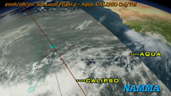
NAMMA Aircraft Flights from Cape Verde [MP4 21MB 640x360]
The NASA African Monsoon Multidisciplinary Analysis (NAMMA) campaign was a field research campaign to study African Easterly waves off the western coast of Africa. A DC-8 aircraft was flown out of the island of Sal, Cape Verde, in August and September 2006, and was outfitted with atmospheric sensors that measured data in this region that could be compared with satellite, balloon, and ground-based sensors to build up a comprehensive picture of the atmosphere in this region. This region is important in that it is one of the primary regions of tropical cyclogenesis, where Atlantic hurricanes form. This animation shows all the flight paths of the DC-8 during this campaign along with the corresponding cloud and satellite data from satellites.
Animation developed by NASA's Scientific Visualization Studio. For additional formats, please visit.

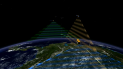
Weather: CloudSat and CALIPSO Help the Study of Meteorology [MP4 8.3MB 640x480]
The study of meteorology presents significant challenges to scientists. One of the most challenging aspects is the inherent complexity of weather coupled with its high rate of change. In the case of clouds, scientists seek new insights into how they form, behave, and interact with the Earth's atmosphere. Engineers designed Cloudsat and Calipso to deliver the data needed by scientists to provide new understanding of how clouds, water vapor, ice particles, and aerosols affect the weather.
Animation developed by NASA's Scientific Visualization Studio. For additional formats, please visit.
Cross Calibration of the Afternoon Constellation's Instruments [MP4 11.1MB 640x360]
The name "A-Train" comes from the formation of international, Earth-observing satellites known as the Afternoon Constellation, which operate in a Sun-synchronous orbit at an altitude of 705 km. The close proximity of the different spacecraft within the A-Train allows for coincident observations between instruments on different spacecrafts, providing scientists additional capabilities in their pursuit of answers about the Earth and its climate. Upon joining the A-train, Glory will help researchers better understand two critical forcings of Earth's climate: atmospheric aerosols and total solar irradiance.
Animation developed by NASA's Scientific Visualization Studio. For additional formats, please visit.
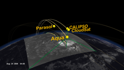
The A-Train Observes Tropical Storm Debby [M4V 21MB 640x360]
The A-Train is a group of spacecraft flying in close formation allowing data taken by each instrument to be correlated to the other instruments providing data synergy. The A-Train includes Aqua, CloudSat, CALIPSO, Parasol, and Aura. The animation begins showing the Earth with moving clouds and with a day/night terminator. Time slows down, and A-train spacecraft orbits are added during a daytime pass. The orbits progress around the globe for 12 hours. During a night time pass the camera zooms into Tropical Storm Debby as the A-train flies over on August 24, 2006. Data sets from some of the A-train's spacecraft/instruments are shown including Aqua/MODIS, CloudSat, CALIPSO, and Aqua/AIRS.
Animation developed by NASA's Scientific Visualization Studio. For additional formats, please visit.